Dogs Leashed

Features
Birding · Fall Colors · River/Creek · Views

Open 8 am to 10 pm daily.
Overview
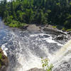
The rough trail on this popular section of the
Superior Hiking Trail (SHT) heads by many waterfalls
and has a magnificent lake view at the east end. This featured hike has sections that are hilly and rocky, with some boardwalks, too.
Description
To access this loop, head to the DOT Wayside parking area of Hwy 61 (44 miles north of Duluth). Head northwest on the
Split Rock River Spur as it climbs parallel to the Split Rock River up to the first falls by Strand Creek.
Just past these first falls, the trail intersects with the
Superior Hiking Trail (SHT). Turn right and continue the ascent past another falls, marking three-quarters of a mile from the start.
Continue along Split Rock River to the high point, just under 2.5 miles. This wil be right before the easternmost point of the loop and has terrific views back east toward the lake. Make the bend to the right (east) and begin the descent past the southeast Split Rock campsite.
At just over 3.5 miles, the trail will leave the river heading southeast toward a shelter and overlook at mile 4.6. Just past this point, look for the
SHT - Merrill Logging Trail Connector to the right and take this short connector to the
Merrill Logging Trail.
Turn right onto the
Merrill Logging Trail for a few hundred yards toward Hwy 61. At the highway, look for the driveway that connects to the paved
Gitchi-Gami State Trail pathway which is a great way to stay off the road on a multi-use path for the final leg to the parking area.
History & Background
The
Superior Hiking Trail (SHT) was part of the REI Every Trail Connects Campaign in 2015 and received an $85,000 grant for trail work to complete the southern end of the long distance trail and several loops for visitors just outside Duluth.
Contacts
Shared By:
Zander Göpfert

 Continue with onX Maps
 Continue with Facebook


 Particularly Special Place


 Intermediate/Difficult


1 Comment