
 Continue with onX Maps
 Continue with Facebook


 Particularly Special Place


 Difficult
Difficult
Difficult
 Difficult
Land Manager: NPS - Yosemite
 Tuolumne Grove of Giant Sequoias
2.7 mi 4.4 km • 496' Up 151.1 m Up • 496' Down 151.09 m Down

 Yosemit…, CA
 Dewey Point
8.0 mi 12.8 km • 835' Up 254.57 m Up • 834' Down 254.3 m Down
Yosemit…, CA
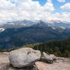
Sentinel Dome
2.1 mi 3.4 km • 350' Up 106.59 m Up • 349' Down 106.51 m Down
Yosemit…, CA
 John Muir Trail (JMT)
182.7 mi 294.0 km • 43,234' Up 13177.7 m Up • 32,854' Down 10013.9 m Down
Yosemit…, CA
Vernal and Nevada Falls Loop
6.2 mi 10.0 km • 1,999' Up 609.27 m Up • 1,998' Down 608.87 m Down
Yosemit…, CA
 Mirror Lake Loop
4.7 mi 7.6 km • 290' Up 88.29 m Up • 289' Down 88.22 m Down


0 Comments