
 Continue with onX Maps
 Continue with Facebook


 Particularly Special Place


 Intermediate
Intermediate
Intermediate
 Intermediate
Local Club: Yellowstone Association
Land Manager: National Park Service - Yellowstone National Park
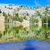
 Sky Rim - East
17.6 mi 28.3 km • 3,261' Up 993.89 m Up • 3,338' Down 1017.27 m Down
 Gardiner, MT
Gallatin Crest Trail
Gardiner, MT
Gallatin Crest Trail
23.7 mi 38.1 km • 5,046' Up 1537.98 m Up • 3,626' Down 1105.35 m Down
Big Sky, MT
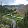
 Beaver Ponds Loop
5.4 mi 8.6 km • 618' Up 188.44 m Up • 617' Down 187.92 m Down
Sphinx Mountain
12.4 mi 19.9 km • 4,728' Up 1441.04 m Up • 4,727' Down 1440.77 m Down
Big Sky, MT
Lava Creek Trail
4.7 mi 7.6 km • 218' Up 66.47 m Up • 844' Down 257.23 m Down
 Summit Climb (Bone Crusher)
2.3 mi 3.7 km • 1,903' Up 580.15 m Up • 1,903' Down 580.17 m Down
Big Sky, MT


0 Comments