Counter-clockwise or clockwise, tough decision. The top of
Burma Road is the highpoint, steep going up the face, go the other way and you gradually climb up. Most of the trail is singletrack comprised of packed gravel. There is good footing except for the steep portion between the canal and
Wolf Tree Trail. The
Burma Road section is an old BLM fire road. This trail is fabulous because you make a transition from the river bottom and its unique ecosystem to the top of Burma where you start getting into more forest. Then you hit the backside high desert plains, and eventually head back into the river. Of course, you'll get high and wonderful overlooks along the Monument Ridge.
$5 parking fee for Smith Rock State Park. Parking is an issue during busy weekends. Hot months bring extra water. Really, bring extra water.
There are 3 parking lots in Smith Rock State Park, plus the bivouac area, plus the parallel parking along the fence, plus along side the road. This route starts at the metal gate in the middle of the main parking lot facing the pay machine on your right. Just follow the path toward the ravine. When you see the covered picnic table you'll know you are close to the start. Directly after the table is an overlook. From the overlook, you can see into the ravine where you'll have to find the bridge.
Hike down the
Chute Trail to the bridge and cross. Decision time. Turn right to take the loop counter-clockwise. This way gets the steepest part of the trail out of the way in the beginning, then it's a slow downhill cruise. Turning left to take this loop clockwise allows you to gradually gain altitude, then drop steeply down the
Burma Road.
The direction described here takes the loop counter-clockwise.
After crossing the bridge turn right onto
Wolf Tree Trail. This will follow the river and slowly curve around to the right. When you pass the horse ford you'll then be on
Burma Road, start watching the cliff's to your left. There are nesting Golden Eagles in this area. There are at least seven established nests, but only one is occupied each year. There will be a sign that says Student Wall and
Burma Road, keep right on
Burma Road. At this point you'll begin an ascent of close to 1,000ft over the next 1.75 miles. Pretty good huff and puff. One zig and a zag you reach the irrigation canal. If it is running, don't let your pets or small children get too close to the crumbly edge.
You'll follow the doubletrack across the face of the Marsupial Range to reach the top. Stop often to rest and take pictures. Once you gain enough elevation, you can observe Mt. Bachelor to the SW, the Three Sisters Mountains to W-SW, Mt. Jefferson to the W, and on a good day, Mt. Hood to the NW. Not to mention getting really good views of Smith Rock and the
Misery Ridge Trail.
Once on top, you can take off on the Gray Butte Trail for about another 20+miles of hiking/biking.
Following this trail to the west, you'll get the dull pleasure of many switchbacks, then the trail will bear off the west and you start approaching the tops of the Monument Range. You can sneak over the edge for some breathtaking views, there are some areas marked as sensitive, please be respectful.
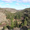
The trail continues to wander down the backside through trees and is a delightful romp through the high desert ecosystem. As the trail turns back to the south you'll descend back into the river environment.
As you descend to the river you'll be able to observe the back side of the Monkey Face Spiral, and as you walk around it, you'll get a close-up of the Monkey "Face". Dilemma time comes again when you reach an intersection with the
Mesa Verde Trail. Either choose taking a left on
Mesa Verde Trail, or continue on the
River Trail.
Continuing on the
River Trail will take you along the river, around Southern Tip and then back to the bridge. Bear left and the
Mesa Verde Trail will join the
Misery Ridge Trail and take back over the top of the ridge. The latter cuts about a mile off the loop, but adds another 700 feet up, then 700 down to the hike.
I chose the
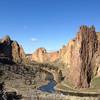
River Trail around the Southern Tip of Smith Rock. The diversity of the river ecosystem combined with coloration and erosion patterns of the south side of Smith Rock exhibit world-class beauty. This area is the reason this State Park was named one of the Seven Wonders of Oregon.
Just follow the
River Trail back to the bridge you first came across and cross back. At this point, you'll be faced with the most difficult hill in the park, the
Chute Trail. It is not any steeper than the rest, it is very short, but you'll definitely feel the burn. An easier alternative is to follow the service road (Canyon trail connector) to the right and back to the parking lot.
From river valley to high desert, this park has a wonderful transition through several ecosystems. Watch for Golden Eagles and Falcons as they both nest along this trail. Watch for ducks, geese, river otters, falcons, marmots, deer, and the once-every-decade-or-so Mountain Lion.

 Continue with onX Maps
 Continue with Facebook


 Particularly Special Place


 Intermediate/Difficult

 Misery Ridge Loop

 Terrebonne, OR
 Whychus Canyon Loop
 Shevlin Loop Trail


0 Comments