Dogs Leashed

Features
Geological Significance · River/Creek · Views · Wildlife

One Way Only: This is designated as a directional trail.
Overview
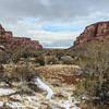
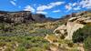
This is a mild and relatively short loop on the east side of BLM lands where the scenery is fantastic.
There are also a series of signs along the way to educate the public on the local terrain and ecology.
Need to Know
Hike in a clockwise direction only.
Description
The hike starts out with a moderate incline on a doubletrack dirt road. It's fairly steep but doesn't last too long before leveling out on mellow singletrack.
The singletrack winds gently up and down for a bit as it makes it's way right up to the edge of the rim, well above the Colorado river. The trail's exposure gives an overwhelming sense of the massiveness of this area. There are also a few opportunities to hike out to the edge of the rim and look down on the river. The trail then heads back inland from the river and descends over slickrock-type terrain. Slightly past halfway on the loop it splits (it shows on the hiking project app, but not on the webpage), with the left being a continuation of Rustler's loop and the right being a cut-back road that heads straight back to the trailhead - either will take you back to the starting point.
The trail climbs a bit more up some rocky but mostly gentle sections before descending gently back to the start.
Contacts
Shared By:
Nicholas Shannon
with improvements
by Kristina Gilday

 Continue with onX Maps
 Continue with Facebook


 Particularly Special Place


 Easy
Easy

 4.3 (7)


 All Clear


0 Comments