Dogs Unknown

Features
Views · Wildflowers · Wildlife
Description
A short path east from the Centennial trailhead and parking area along the north side of Sunshine Canyon Drive takes users to a picnic pavilion next to a stream. Pass through the pavilion, cross the concrete bridge and head left and uphill through a small meadow. Signage marks the official start of the Mount Sanitas Trail where it crosses the Silver Lake Irrigation Ditch.
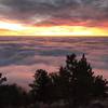
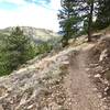
The trail contours around the west flank of Mount Sanitas, climbing steeply up wooden stairs and rock ledges to gain elevation in a hurry. The difficult ascent rewards with views down into Sunshine Canyon and west to the impressive Indian Peaks. Pass below short cliffs popular with bouldering climbers and spot their favorite routes by looking for white, chalky holds.
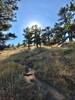
The terrain mellows slightly as it reaches the Mount Sanitas ridge and then meanders back and forth along its spine. Clamber ever upwards catching glimpses of false summits and the city below. Much of the middle section of this trail consists of rock steps clinging to the sunny hillside. The remainder of the trail climbs steadily to the summit past ponderosa pines and springtime wildflowers.
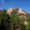
One final push and you find yourself on top of the rocky summit outcrop. Settle down for a well deserved rest with the all the other sweaty trail runners, hikers and their very fit dogs. Enjoy the best views of Boulder laid out to the east, as trees partially obscure views in other directions.
Flora & Fauna
Note that mountain lions and bears pass through this area and although rangers do their best to put up warning signs about recent activity, dawn and dusk are the times to be most aware.
Contacts
Shared By:
Megan W

 Continue with onX Maps
 Continue with Facebook


 Particularly Special Place


 Difficult

 4.3 (30)


0 Comments