Dogs No Dogs

Features
Commonly Backpacked · Geological Significance · River/Creek · Swimming · Views

The first 7 miles of this route (to Zion National Park) are managed by the BLM and that agency does not restrict visitation to this portion due to weather concerns or flood risk. You'll need a permit to continue on into the park and it does not issue wilderness or camping permits when the river's flow is 120 cfs or greater. The route can be closed by Spring snowmelt and by desert monsoon flash floods. Obtain permits and weather information from the park before starting this hike.
Need to Know
There is a vault toilet at the trailhead. No overnight camping is allowed there. There are no amenities along this route other than at the trailhead. A good portion of this route is through narrow canyons that are susceptible to flash floods and would be difficult to escape from if that should happen. Do not attempt to go through these canyons if there is a risk of rain or flash flooding.
The full 16-mile hike (or backpack) between the Chamberlain's Ranch and Temple of Sinawava Trailheads can be done in a long day but is more comfortably done in two days. You'll be walking in the river for most of this route. The river's cold water and the rounded, submerged river rocks in its bed make for tiring and challenging footing. Walking for hours over these rounded rocks can make your feet extremely sore if you are wearing flimsy shoes. Supportive boots that you are willing to get wet are a better choice.
Description
The route into
The Narrows from Chamberlain's Ranch Trailhead generally follows the river, as there is no developed trail. The route starts out in mostly open country but after about 3.5 miles the canyon's sandstone walls become increasingly narrow and dramatic. At about 7 miles, you cross into Zion National Park, so be sure you have obtained the appropriate wilderness and camping permits.
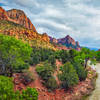
Although none of the canyons along this route are as singularly spectacular as
The Narrows, they are nonetheless absolutely amazing and they go on for miles. This hike along soaring walls, through sandstone grottos, past natural springs, and below hanging gardens can be an unforgettable wilderness experience.
Contacts
Shared By:
BK Hope

 Continue with onX Maps
 Continue with Facebook


 Particularly Special Place


 Intermediate/Difficult


0 Comments