Hiking Project Logo

Prepare to tackle one of the most physically-difficult treks in the world. The hike can take five to seven days.


Your Rating: Rating Rating Rating Rating Rating      Clear Rating
Your Difficulty:
Your Favorites: Add To-Do · Your List
Zoom in to see details
Map Key

15.7

Miles

25.2

KM

Point to Point

3,844' 1,172 m

High

497' 151 m

Low

5,906' 1,800 m

Up

2,724' 830 m

Down

10%

Avg Grade (6°)

43%

Max Grade (23°)

Dogs Unknown

Features 
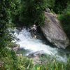
Birding · River/Creek · Spring · Views · Waterfall · Wildflowers · Wildlife

Need to Know

Avoid the wet season and flooding October-November.

Description

Trek to the Lost City of the Tayronas! It was missing for 100s of years before being rediscovered in 1972, only to endure decades of guerrilla warfare afterward.

Today, most anyone can attempt the hike. You should be prepared to tackle one of the most physically-difficult treks in the world, according to the local guides. The hike takes you through indigenous lands and rivers that can get dangerous during the wet season. The view from the top is more than worthwhile.

Contacts

Land Manager: Región Caribe MTB

Shared By:

Joseph States

Trail Ratings

  5.0 from 2 votes

#1

in Colombia

#1919

Overall
  5.0 from 2 votes
5 Star
100%
4 Star
0%
3 Star
0%
2 Star
0%
1 Star
0%
Trail Rankings

#1

in Colombia

#2

in Colombia

#1,919

Overall
2 Views Last Month
22 Since Jan 17, 2021
Difficult Difficult

0%
0%
0%
0%
100%
0%

Photos

Crossing the Rio Buritaca
Jan 17, 2021 near Ciénaga, CO
Village
Jan 17, 2021 near Ciénaga, CO
Ciudad Perdida
Jan 17, 2021 near Ciénaga, CO

0 Comments

Current Trail Conditions

Unknown
Add Your Check-In

Check-Ins

none
Welcome

Join the Community

Create your FREE account today!
Already have an account? Login to close this notice.

Get Started