
 Continue with onX Maps
 Continue with Facebook


 Particularly Special Place


 Intermediate

 Intermediate
Land Manager: USFS - Inyo National Forest Office
 Mono Pass Trail to Summit Lake
4.1 mi 6.5 km • 1,773' Up 540.49 m Up • 142' Down 43.37 m Down
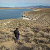
 Crowley Lake Columns Hike
3.7 mi 6.0 km • 345' Up 105.23 m Up • 346' Down 105.35 m Down
 Bloody Mountain via Laurel Lakes Road and the Northeast Ridge
14.1 mi 22.7 km • 5,100' Up 1554.34 m Up • 5,099' Down 1554.03 m Down
Mammoth…, CA
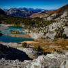
Mammoth Crest - Duck Pass Loop
13.2 mi 21.2 km • 2,875' Up 876.21 m Up • 2,890' Down 880.93 m Down
Mammoth…, CA
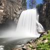
Upper and Lower Rainbow Falls
3.5 mi 5.7 km • 408' Up 124.4 m Up • 408' Down 124.37 m Down
 Mammoth…, CA
Agnew Meadow to Lower Rainbow Falls (JMT Route)
Mammoth…, CA
Agnew Meadow to Lower Rainbow Falls (JMT Route)
11.8 mi 19.0 km • 696' Up 212.22 m Up • 1,443' Down 439.9 m Down


0 Comments