
 Continue with onX Maps
 Continue with Facebook


 Particularly Special Place


 Intermediate

 Intermediate
Local Club: Ashfield Trails
 Mohawk Trail Loop
5.1 mi 8.2 km • 1,133' Up 345.45 m Up • 1,119' Down 341.09 m Down
Charlemont, MA
 Robert Frost Trail
40.2 mi 64.7 km • 5,360' Up 1633.58 m Up • 5,892' Down 1795.84 m Down
Wendell, MA
 Leyden Blueberry Fields
7.5 mi 12.1 km • 1,167' Up 355.66 m Up • 1,188' Down 362.11 m Down
Bernard…, MA
Mount Greylock Summit Loop
6.6 mi 10.7 km • 2,251' Up 686.23 m Up • 2,246' Down 684.66 m Down
 Adams, MA
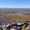
Goat Peak Out-and-Back
Adams, MA
Goat Peak Out-and-Back
0.9 mi 1.5 km • 277' Up 84.39 m Up • 277' Down 84.49 m Down
Eastham…, MA
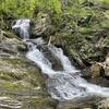
Sanderson Brook Falls Trail
2.0 mi 3.2 km • 238' Up 72.54 m Up • 239' Down 72.79 m Down


0 Comments