Dogs Leashed

Features
Birding · Fall Colors · Fishing · Lake · River/Creek · Swimming · Views · Wildflowers · Wildlife

James Peak Wilderness Rules apply. Parking on the County Road 275 will get you ticketed.
Overview
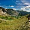
From the trailhead, there is a moderate incline until you come out above the glacier. The next mile is through tundra, entering James Peak Wilderness. Fantastic mountain range views and great wildflowers in the basin while making the approach to James Peak. Once at the peak, it provides a great 360-degree view of the Front Range mountains. Deer, birds, marmots, and fox are prolific in the area early in the morning.
Need to Know
$20 cash only fee for both parking lots - no parking on CR275.
Description
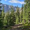
The trail begins on a wide rocky road - stay left at all the offshoots. You'll quickly ascend and arrive at Saint Mary's Lake. Continue across a bridge and make your way up the glacier. There are multiple options - with good traction you can go straight up the glacier or if you do not have good traction, there are trails along either side of the glacier.
Follow the well-defined trail until you come across the jeep road where you'll need to continue straight and cross the tundra - there is not a defined trail. You'll meet at the CDT. From this point, the trail is clearly defined to the summit. As you ascend the trail you'll come into view of Loch Lomond, Ice Lake, Mt. Flora, Bancroft, Perry, and Eva, as well as Mt. Evans, Bierstadt, and Gray's and Torreys to the south.
The trail from the tundra basin heads up parallel with the ridge and cuts north just before mile 4. You may need to cross a snow field dependent on the time of year once the trail turns away from the ridge.
Contacts
Shared By:
Chelsea Taylor
with improvements
by Eden Sabala

 Continue with onX Maps
 Continue with Facebook


 Particularly Special Place


 Intermediate

 4.8 (8)


 All Clear


0 Comments