
 Continue with onX Maps
 Continue with Facebook


 Particularly Special Place


 Difficult
Difficult
Difficult
 Difficult
Local Club: The Shenandoah National Park Trust
Aug 9, 2023: Into the Wild: Improving Access to the Outdoors
Jul 31, 2023: The Intern POV: Time & a Place at the Table
Jul 5, 2023: The Intern POV: A Fish out of Water
Land Manager: NPS - Shenandoah National Park
 Limberlost Trail
1.4 mi 2.2 km • 172' Up 52.44 m Up • 161' Down 49.06 m Down


 AT/Passamaquoddy/Furnace Springs Loop
2.8 mi 4.5 km • 591' Up 180.22 m Up • 605' Down 184.28 m Down
 Nicholson Hollow
11.6 mi 18.6 km • 2,092' Up 637.62 m Up • 2,093' Down 637.95 m Down
 Story of the Forest Trail
1.0 mi 1.5 km • 93' Up 28.21 m Up • 148' Down 45.1 m Down
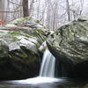
Lewis Falls Trail
1.8 mi 2.9 km • 706' Up 215.34 m Up • 451' Down 137.42 m Down
Bearfence Loop Trail
1.1 mi 1.8 km • 232' Up 70.77 m Up • 232' Down 70.65 m Down
Stanley, VA


0 Comments