
 Continue with onX Maps
 Continue with Facebook


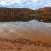
 Particularly Special Place


 Intermediate
Intermediate
Intermediate
 Intermediate
Land Manager: Maryland DNR - Patuxent River State Park
 Lake Bernard Frank Loop
3.5 mi 5.7 km • 301' Up 91.76 m Up • 300' Down 91.3 m Down
 Cabin Branch - Hard Rock Loop
4.6 mi 7.4 km • 365' Up 111.23 m Up • 369' Down 112.35 m Down
Cool Spring Run to Loops
4.3 mi 6.9 km • 352' Up 107.44 m Up • 355' Down 108.2 m Down
Seneca Trails Route
32.4 mi 52.1 km • 1,421' Up 433.04 m Up • 1,434' Down 437.2 m Down
Morning Choice and Rockburn Branch
4.4 mi 7.1 km • 325' Up 99.16 m Up • 325' Down 99.15 m Down
Soapstone-Santee-Ridge Loop
8.2 mi 13.1 km • 951' Up 290.01 m Up • 956' Down 291.5 m Down


1 Comment