
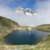
 Seven Lakes with Matterhorn Reflections
9.0 mi 14.5 km • 3,200' Up 975.27 m Up • 967' Down 294.87 m Down
 Zermatt, CH
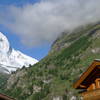
 Matterhorn Trail
5.4 mi 8.7 km • 3,088' Up 941.3 m Up • 55' Down 16.89 m Down
 Zermatt, CH
 Waldweg
5.1 mi 8.2 km • 17' Up 5.07 m Up • 2,114' Down 644.39 m Down
Five Seenweg
5.7 mi 9.2 km • 523' Up 159.53 m Up • 1,552' Down 472.98 m Down
Zermatt, CH
Hornlihutte
5.0 mi 8.1 km • 2,245' Up 684.39 m Up • 2,245' Down 684.3 m Down
Zermatt, CH
 TOR330_2022_VAR_OYACE
213.9 mi 344.2 km • 78,549' Up 23941.8 m Up • 78,525' Down 23934.3 m Down
Martign…, CH

 Continue with onX Maps
 Continue with Facebook


 Particularly Special Place


0 Comments