Dogs Unknown

Features
Views
Overview
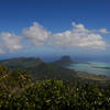
This is the route from the Moka District. The trail is easy, although rocky, until the final stretch up the "thumb" which gets very steep and has some exposure. You'll have excellent views of Moka, Port Louis, Snail Rock, Pieter Both (the second highest peak famous for a balanced-rock summit), Berthelot Peak, and much more. The very top is very small with steep edges so it may not be comfortable if crowded.
Need to Know
Parking at the trailhead is limited and space at the summit is limited.
Description
Parking for this hike sounds hard to find, but it's not that bad. Head towards Moka and pick up B47/Bois Cheri Road. This road will have a sharp bend in the northwest corner of Moka. Just to the east of the bend look for a tiny farm road that has a decent sized brown sign for Le Pouce. This single-lane road heads northeast to a small parking area. There is only room for a few cars in the parking area, but more can parallel park along the edge of the road. The summit is visible from here.
The trail begins by continuing in the same direction as the road towards the northeast, but now as a 4X4 farm road between fields of sugar cane. The road bends a little towards the northwest and gains some easy elevation. You'll come to a random small gazebo thing right after which the trail departs the farm road. After this the trail gets rockier and a little steeper, but still resembles an old 4X4 road. It bends the the northwest and enters thick shady forest. You'll gain some ground and turn some switchbacks in the forest. Soon you'll exit the trees and the views get great. The trail heads west along massive rock-cuts for the old road that offer clear views to the east and south. Berthelot Peak to the south is especially prominent.
The trail will bend around the western end of Le Pouce on a wide cut-out-switchback. After this you'll get great views to Snail Rock and behind it Port Louis. You'll encounter the route to Le Pouce from Port Louis in the meadows shortly. Follow the now-singletrack trail through thick brush to the east. This section of trail is easy going, but the clay-like dirt can be slick when wet. You'll get a few excellent view points, including a nice grassy field just before the final ascent begins that is perfect for a rest/snack. Pieter Both, the second tallest peak with it's famous balanced-rock summit, is clearly visible from here.
The final ascent up the "thumb" (Le Pouce means The Thumb, FYI) is where the trail gets challenging. It can be very narrow and steep. Some sections will require small amounts of scrambling to get over rocky ledges. Some parts head along catwalks with quite a bit of exposure. However, it's over before you know it and you'll be at the top! The summit offers incredible 360 degree views of nearly the entire island. Port Louis is clear to the west, Pieter Both to the east, numerous peaks to the north and south, and even Piton de la Petite Riviere Noire is visible far to the south on clear days.
The downside to the summit is that it is very small with very steep edges. It can feel crowded with as few as six people, and anymore than 10 might be uncomfortable. The final route up the summit is also too narrow to provide anywhere to "wait" for the summit. If you see a big group headed up before you, you may want to just hang out at the meadow overlook for a bit until they come back down.
Return the way you came.
History & Background
Charles Darwin ascended Le Pouce on 2 May 1836.
Shared By:
Karl W

 Continue with onX Maps
 Continue with Facebook


 Particularly Special Place


 Difficult


0 Comments