The Harvey Bear Ranch Hike travels over Coyote Ridge from its grass covered western side criss-crossed by seasonal streams, to its wooded eastern side and Coyote Lake. Then the route goes north through sunlit woods with an abundance of spring wildflowers. From here, there is a scenic climb to a spectacular high viewpoint on Coyote Ridge, and then back down to return to where the Harvey Bear Ranch Hike began.
The start of the Harvey Bear Ranch Hike can be found on San Martin Avenue at the Harvey Bear Ranch Entrance to Coyote Lake - Harvey Bear Ranch County Park. Here, the hike begins on
Willow Springs Trail.
Willow Springs Trail and Coyote Ridge Trail (start - mile 2.5)
Willow Springs Trail climbs gradually and continually as it winds its way through grass hills studded with oak trees. The golden grasses of summer and autumn become bright green with patches of yellow mustard in the winter and spring when the rains come. Looking behind (south, southwest, west, and northwest), there are expansive views of rural southern Santa Clara Valley, and the forested, dark green Santa Cruz Mountains in the far distance. The trail heads towards Coyote Lake, which comes into view after 1.8 miles where
Willow Springs Trail ends at
Coyote Ridge Trail.
Go right onto
Coyote Ridge Trail that goes through sunlit woods and meadows with views of Coyote Lake below. After .7 miles on
Coyote Ridge Trail,
Calaveras Trail is reached.
Calaveras Trail (mile 2.5 - 4.8)
Go left onto
Calaveras Trail and cross a grassy meadow with Coyote Lake below. Passing
Valley Oak Trail, continue on
Calaveras Trail and enter thin, grassy oak woods as the trail travels north.
Calaveras Trail runs along the gently sloping east side of Coyote Ridge, about halfway up the ridge. It is a fairly flat trail, going through alternating sections of thin woods and open meadows. Coyote Lake can be seen below through breaks in the trees. In the spring, there is an abundance of wildflowers of many varieties. Some meadows and hillsides are carpeted with them, especially on the northern half of the trail—it's quite a display!
Ed Willson Trail and Harvey Bear Trail (mile 4.8 - 8.5)
From
Calaveras Trail, go left onto
Harvey Bear Trail that runs through grassy hills with stands of oak trees. This area is pasture land, and many cows can be around and on the trail. Be nice to them.
After 0.2 miles on
Harvey Bear Trail, go right onto
Ed Willson Trail and climb steadily for 1.8 miles.
Ed Willson Trail continues through grass hills that are used as pasture land for its first 0.3 miles. After that, the trail goes through alternating sections of woods and meadows with a variety of wildflowers in the spring. After 1.0 mile on
Ed Willson Trail, there are two switchbacks. By the second switchback, with the altitude gained, the views are quite expansive. But the best is yet to come...
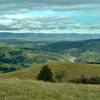
After the second switchback, the high point of
Ed Willson Trail is reached. Looking south, there is a vast panorama of pretty much everything. Palassou Ridge that forms the east side of Coyote Lake/Creek Valley, Coyote Lake, Coyote Ridge with several of its high points (lower than the viewer) including Mummy Mountain, the rural southern Santa Clara Valley, Central California in the far distance, and Santa Cruz Mountains can all be seen. Wildflowers, and butterflies playing in them, add to the wonder. This is a great place to take a nice long break and have a snack.
From its high point,
Ed Willson Trail descends continuously on the grass covered west side of Coyote Ridge for the next 1.1 miles. Enjoy wildflowers and views of southern Santa Clara Valley to the west along this descent. At the bottom of this section, the grasslands are used as pastures, so there are cows again.
Ed Willson Trail ends at
Harvey Bear Trail. Turn right onto
Harvey Bear Trail for .5 miles to get to
Townsprings Trail.
Townsprings Trail (mile 8.5 - end)
Go left onto
Townsprings Trail and continue descending the grassy western side of Coyote Ridge. A few seasonal streams are passed. In the spring, the yellow mustard grows head high here. After 1.4 miles on
Townsprings Trail,
Willow Springs Trail is reached. Go right onto
Willow Springs Trail and descend gradually for 1.0 mile through the grass hills, passing seasonal streams, to return to the parking area.
Deer, wild pigs, and cows can be found here. Birds abound as well—common ones are yellow-billed magpies, red-wing blackbirds, steller's jays, and hawks. The route goes through grass hills and woods dominated by oaks. There is an abundance and large variety of wildflowers blooming in the spring across the varied terrain.

 Continue with onX Maps
 Continue with Facebook


 Particularly Special Place


 Intermediate/Difficult

 Coyote Lake and Ridge Hike

 Gilroy, CA
 Bald Mountain Out and Back
 Monument Peak Loop via BART


0 Comments