Use onX Backcountry to explore the terrain in 3D, view recent satellite imagery, and more.
Now available in onX Backcountry Mobile apps!
For more information see this post.
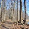
This is a short hike around the picnic area with lots of trees on the sides of the woods. It seems to be used very infrequently. It does merge with the Schoen Creek Trail for a few hundred feet at the back of the trail and then bears left away from it.
We use cookies to improve your browsing experience, to show you
personalized content, and for statistical purposes. By continuing
to navigate our website, you accept our use of cookies. Read our
Privacy Policy to learn more.


 Continue with onX Maps
 Continue with Facebook


 Particularly Special Place


0 Comments