
 Continue with onX Maps
 Continue with Facebook


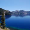
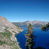
 Particularly Special Place


 Difficult
Difficult
Difficult
 Difficult
Land Manager: USFS - Umpqua National Forest Office
 Cleetwood Cove Trail
2.1 mi 3.4 km • 619' Up 188.58 m Up • 619' Down 188.69 m Down

 Crater…, OR
 Wizard Island Summit Trail
2.5 mi 4.0 km • 736' Up 224.3 m Up • 736' Down 224.2 m Down
Crater…, OR
 Sun Notch Trail
0.5 mi 0.8 km • 129' Up 39.37 m Up • 70' Down 21.37 m Down
Crater Peak Trail
2.8 mi 4.5 km • 729' Up 222.14 m Up • 217' Down 66.03 m Down
Mount Scott Trail
4.5 mi 7.2 km • 1,236' Up 376.74 m Up • 1,236' Down 376.88 m Down
Crater…, OR
Union Peak
10.0 mi 16.1 km • 1,638' Up 499.35 m Up • 1,638' Down 499.31 m Down


0 Comments