Dogs Unknown

Features
Views

Make sure to get both a Nepal tourist visa and a trekking permit.
Need to Know
Notably, altitude sickness can occur at High Camp (3500m) and above, which may cause painful headaches, nausea, and vomiting. Make sure to drink at least 3 liters of water per day. If symptoms persist, travel down at least 500m. Death or serious injury may occur if you do not descend immediately. Weather can be fickle, so bring gear for heat, cold, and rain. A guide for this trek is highly recommended as they will keep you safe and oriented.
Description
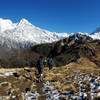
From Middle Camp at Badal Danda, it is a short three hour hike up to High Camp. Altitude sickness may occur here at higher elevations. You'll potentially start seeing snow here depending on the season. The views along this ridgeline trail are spectacular.
Shared By:
Missouri Hiker

 Continue with onX Maps
 Continue with Facebook


 Particularly Special Place


 Intermediate


0 Comments