The Letora Trail starts from the junction of the
Huckleberry Trail and the
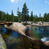
Kibbie Ridge Trail. It immediately makes a wide, sandy ford of the East Fork of Cherry Creek and passes the grassy, east shore of Huckleberry Lake. There is a large flat packer's camp here under the trees.
When the trail first rounds the north shore and starts to climb, I found it hard to follow. It is up the rocky slope, about 100 feet higher than the lake. After this section, I had no problems following the trail.
As the main trail swings around to the northeast shore, there are a couple of trails of use that lead down to small, but great, campsites near the lake. Looking down as the trail continues to climb higher and away from the lake, it seems like the most beautiful places to camp would be a little further down the northeast shore, but I am not sure how easy it would be to reach that area or to find campsites.
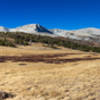
The continuing trail seems designed to climb from one wide rocky ledge to another, each overlooking Huckleberry Lake from a higher vantage point. When it finally reaches the highest ledge, the trail swings north, drops down to pass a large pond, and then climbs slightly to reach the southern shore of Letora Lake.
Letora is an exceptionally beautiful lake that would be well worth a day of visiting, swimming, and exploring. It is long, with polished granite islands and inlets, and surrounded by forest and flowers.
The trail only touches Letora Lake at this one point. It then moves away from the lake, descending slightly to the junction with the
Bell Meadow Trail. The junction is simply a post pointing to Wood Lake in one direction and Letora Lake in the other.
There used to be a trail leading from this spot down past the trail to Olive Lake and onto a junction with the
Kibbie Ridge Trail west of Huckleberry Lake. This trail is no longer signed at either end. I tried to climb up it from the
Kibbie Ridge Trail, but I was unable to find my way in the short time that I had available.

 Continue with onX Maps
 Continue with Facebook


 Particularly Special Place


 Intermediate


0 Comments