
 Continue with onX Maps
 Continue with Facebook


 Particularly Special Place


 Very Difficult
Very Difficult
Very Difficult
 Very Difficult
Land Manager: USFS - Shoshone National Forest Office
 Stough Creek Basin Backpack
20.1 mi 32.4 km • 2,945' Up 897.68 m Up • 2,945' Down 897.54 m Down
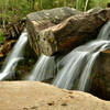
 Popo Agie Falls Trail
3.3 mi 5.3 km • 670' Up 204.27 m Up • 670' Down 204.2 m Down
 Lander, WY
Popo Agie Nature Trail Loop
Lander, WY
Popo Agie Nature Trail Loop
2.4 mi 3.9 km • 333' Up 101.65 m Up • 333' Down 101.46 m Down
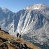
 Big Sandy Cirque of the Towers
16.6 mi 26.7 km • 2,320' Up 707.02 m Up • 2,320' Down 707 m Down
Lander, WY
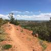
 Big Sandy Lizard Towers Loop
40.4 mi 65.1 km • 5,918' Up 1803.87 m Up • 5,918' Down 1803.93 m Down
Big Sandy, WY
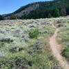
Johnny Draw to Red Ridge
4.3 mi 7.0 km • 660' Up 201.28 m Up • 661' Down 201.34 m Down
Lander, WY


0 Comments