Dogs Off-leash

Features
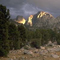
Birding · Lake · River/Creek · Views · Wildlife
Overview
The East Bay Regional Park District offers a free Trails Challenge program every calendar year; see
ebparks.org/TrailsChallenge ... Each year, twenty trail routes from all over the District are suggested, grouped into "easy", "moderate", and "challenging" categories. This route is the "challenging" route for 2017 in Anthony Chabot Regional Park.
Need to Know
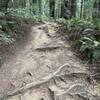
Most of
Towhee Trail and this route's portion of
Redtail Trail are singletrack trails that are open to bicycles as well as to hikers and equestrians. All trail users should be aware that they may encounter other trail users moving at different speeds and having different needs. The standard trails right-of-way rule applies–bicycles yield to all other modes of travel and all other modes of travel yield to equestrians–but being courteous is always the right thing to do. Call out and make voice contact! How can I safely pass you? Thank you and have a good trip! If you or someone you encounter is lost, ill, or injured, or in any other sort of emergency, call 510.881.1121 from your cellphone (911 from a landline) to reach Regional Parks Public Safety 24 hours a day.
Description
This is a loop route, including an out-and-back "lollipop stick" tail at the beginning and end. There is ample free parking available at Marciel Gate, at the junction of Redwood Road and Marciel Road. From Marciel Gate, follow
Redtail Trail toward the southeast. Turn right on
Deer Canyon Trail, then left on
Brandon Trail, then right on
Two Rocks Trail, then left on
Columbine Trail, then left on
Honker Bay Trail, then left on
Towhee Trail, then left on
Brandon Trail, then right on
Redtail Trail. Follow this trail back to the beginning.
Contacts
Shared By:
John Rabold

 Continue with onX Maps
 Continue with Facebook


 Particularly Special Place


 Intermediate

 4.4 (9)


0 Comments