
 Continue with onX Maps
 Continue with Facebook


 Particularly Special Place


 Intermediate

 Intermediate
Land Manager: USFS - Lincoln National Forest Office
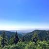
 Rim Trail Out-and-Back
23.2 mi 37.3 km • 3,088' Up 941.21 m Up • 3,088' Down 941.28 m Down
 La Luz, NM
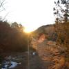
 Fresnal Canyon Rails-to-Trails
8.9 mi 14.4 km • 767' Up 233.7 m Up • 767' Down 233.68 m Down
Alamo Canyon Loop
6.3 mi 10.1 km • 1,246' Up 379.74 m Up • 1,248' Down 380.44 m Down


0 Comments