
 Continue with onX Maps
 Continue with Facebook


 Particularly Special Place


 Difficult
Difficult
Difficult
 Difficult
 Upper McCord Creek Falls
1.8 mi 2.9 km • 412' Up 125.63 m Up • 412' Down 125.52 m Down

 Cascade…, OR
 Munra Point Out and Back
6.2 mi 10.0 km • 2,173' Up 662.39 m Up • 2,205' Down 672.21 m Down
Cascade…, OR
 Beacon Rock Summit Trail
0.8 mi 1.3 km • 555' Up 169.25 m Up • 550' Down 167.63 m Down
Stevenson, WA
 Eagle Creek Trail to Tunnel Falls
11.7 mi 18.8 km • 1,280' Up 390.28 m Up • 1,280' Down 390.29 m Down
Cascade…, OR
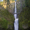
Multnomah Falls Loop
4.8 mi 7.7 km • 1,554' Up 473.69 m Up • 1,510' Down 460.14 m Down
Bridal…, OR
Angel's Rest Lookout
4.1 mi 6.6 km • 1,441' Up 439.21 m Up • 1,439' Down 438.72 m Down
Bridal…, OR


1 Comment