
 Continue with onX Maps
 Continue with Facebook


 Particularly Special Place


 Difficult
Difficult
Difficult
 Difficult
Land Manager: USFS - White Mountain National Forest Office
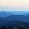
 The Presidential Traverse
19.0 mi 30.5 km • 7,705' Up 2348.41 m Up • 7,131' Down 2173.59 m Down
 Gorham, NH
Pinkham Notch to Mount Washington Summit
Gorham, NH
Pinkham Notch to Mount Washington Summit
8.0 mi 12.8 km • 4,154' Up 1265.99 m Up • 4,152' Down 1265.6 m Down
 Pinkham…, NH
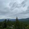
 Black Cap Trail
2.5 mi 4.0 km • 590' Up 179.92 m Up • 589' Down 179.53 m Down
North C…, NH
Old Speck Out and Back
7.0 mi 11.3 km • 2,725' Up 830.46 m Up • 2,724' Down 830.31 m Down
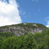
 Bald Mountain/Artists Bluff Loop
1.5 mi 2.4 km • 535' Up 163.11 m Up • 532' Down 162.09 m Down
Franconia, NH
Cannon-Lonesome Loop
5.8 mi 9.3 km • 2,398' Up 730.77 m Up • 2,398' Down 730.82 m Down
Lincoln, NH


 All Clear


0 Comments