
 Continue with onX Maps
 Continue with Facebook


 Particularly Special Place


 Intermediate
Intermediate
Intermediate
 Intermediate
Land Manager: USFS - Uinta, Wasatch & Cache National Forests Office
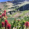
 Devil's Castle/Sugarloaf via Cecret Lake
4.2 mi 6.8 km • 1,759' Up 536.02 m Up • 1,758' Down 535.75 m Down
 Alta, UT
 Stewart Cascades Trail #056
3.6 mi 5.9 km • 680' Up 207.3 m Up • 680' Down 207.27 m Down
 Cedar H…, UT
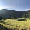
 Brighton Lakes to Sunset Peak
6.1 mi 9.9 km • 1,837' Up 559.87 m Up • 1,833' Down 558.78 m Down
Brighton, UT
Butler Fork
3.3 mi 5.3 km • 1,486' Up 452.87 m Up • 1,485' Down 452.72 m Down
Alta, UT
Deso-Crest-Dog Loop
12.9 mi 20.8 km • 2,770' Up 844.37 m Up • 2,769' Down 843.89 m Down
Alta, UT
Dog Lake and Desolation Lake
8.6 mi 13.8 km • 2,098' Up 639.5 m Up • 2,112' Down 643.72 m Down


0 Comments