
 Continue with onX Maps
 Continue with Facebook


 Particularly Special Place


 Intermediate
Intermediate
Intermediate
 Intermediate
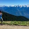
 Hurricane Hill Nature Trail Out and Back
3.2 mi 5.2 km • 702' Up 214.1 m Up • 703' Down 214.3 m Down

 Port An…, WA
 Royal Basin Out and Back
15.6 mi 25.1 km • 3,262' Up 994.15 m Up • 3,264' Down 994.76 m Down
Sequim, WA
 Gray Wolf Loop
43.6 mi 70.1 km • 9,711' Up 2959.79 m Up • 9,718' Down 2962.1 m Down
Gladys Divide
17.6 mi 28.3 km • 4,331' Up 1320.08 m Up • 4,331' Down 1320.12 m Down
Belfair, WA
Lena Lake
6.7 mi 10.8 km • 1,365' Up 416.13 m Up • 1,364' Down 415.69 m Down
Seabeck, WA
Mt. Rose Loop Trail #814
6.5 mi 10.5 km • 3,488' Up 1063.26 m Up • 3,488' Down 1063.16 m Down


0 Comments