Dogs Unknown

Features
River/Creek · Views · Waterfall
Overview
This route starts at Cocora and quickly moves beyond what the typical Cocora visitor sees. However, don't underestimate this. The steepness, the mud, and the altitude conspire to reduce your speed to a fraction of what you are used to. Think of this as a 50k and you'll likely be planning appropriately.
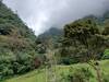
You are unlikely to see anybody up until Primavera, and will have gorgeous views along the way, including Quindio peak, past Buenas Aires, which was snow covered when I saw it, to give you a big mountain feel.
Need to Know
There were no fees I paid along this section. However, it would be good to bring money just in case. Additionally, you may be able to get some food or a drink at Argentina and most likely at Primavera. You may also have to pay a fee to pass through either of these or the property on the southern access to Cocora (I think that was 7,000 COP when I did the shorter loop.
Description
Start from Cocora, as far up the road as the Jeep will take you. Just follow the road up. The trail was easier to follow than I had expected and included pretty good markings along the way. I would always recommend using an app (this should be on both Gaia and TRP) to track yourself, in the event of any confusing. This is most likely to happen coming down from Primavera, but we'll get to that.
Continue to follow the trail up. You'll have to deal with some mud, but nothing too outrageous for this area. You'll get some great views, and you'll want to stop to enjoy them to get a chance to catch your breath.
You'll pass through a few gates and at about 5 miles in you'll hit a trail that heads off to the right. It'll drop down to the river and should cross and connect with the southern end of this loop. This is a good bail point if this longer loop is beginning to look unfeasible. Keep an eye on your time and don't expect to have an amazing pace for the first half of the trail heading back from Primavera. The trail is simply too much of a mess to allow quick movement. For a reference point, it took me approximately 11 hours to do this loop. I did the Dunkin Ridge 50k (lower altitude, but 10k ft of climbing) in 10 hrs. If you are able to use this to gauge yourself and any times/races you have to adjust your expected time up or down from mine.
Assuming you are moving forward from this trail junction, you'll go through a couple of more gates before reaching Finca Argentina. You'll need to slog through their mud pit to get to the other side. From here it isn't too far to Finca Buenas Aires and the views continue to improve as you move in that direction.
Just past Buenas Aires, where you'll have another mud slog, you'll hit the trail junction where you'll turn to the right. You'll drop down to a creek crossing and, weather permitting, start getting some good views of Quindio Norte.
After the water crossing, you'll climb several hundred feet to a ridge line. This is another good time to have a GPS app, as it is a bit of a free for all to the top. At the ridge, find the gate to go through, and you'll be able to descend to Finca la Primavera. This is where the real mess begins. The only thing that prepped you for the next 4 or 5 miles is what you went through at the Fincas.
At Primavera, you'll see a wide path/road heading uphill to the right (about a 90 degree turn from the way you came down). You'll be longing for some downhill, but you'll have to wait, and then you'll get it all at once. The trail gently climbs and is just a muddy mess. It's something you'll just have to see for yourself but know you won't be moving quickly unless you visit during some freakish dry spell. I did this in mid-January, which is supposed to be the dry season, but it rained almost every day.
Just push on and be weary that there is a trail that heads off to the right, before coming back and reconnecting. I don't know if that trail is better or worse. I would bet the same. Again, an app would come in handy during this stretch. Once you are about to lose your mind, you'll hit treeline, and the true descending will start. This point will mark a return to the type of mud and trail you experienced the rest of the way. There is a lot of runable stuff from here on out, some beautiful waterfalls, singletrack, and the requisite mud pits to keep you honest.
From here, just follow the trail back around to Cocora where you can catch the Jeep back to Salento and a much needed shower.
Contacts
Shared By:
Jason Doedderlein


 Continue with onX Maps
 Continue with Facebook


 Particularly Special Place


0 Comments