
 Ostler Lake
12.4 mi 20.0 km • 1,900' Up 578.99 m Up • 1,900' Down 578.98 m Down
 Oakley, UT
 Naturalist Basin Lakes
4.9 mi 7.8 km • 652' Up 198.72 m Up • 651' Down 198.38 m Down
 Oakley, UT
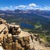
Bald Mountain Trail
Oakley, UT
Bald Mountain Trail
2.8 mi 4.5 km • 1,132' Up 344.89 m Up • 1,131' Down 344.7 m Down
Grandaddy Basin Out and Back
13.8 mi 22.3 km • 1,785' Up 544.16 m Up • 1,785' Down 544.04 m Down
Uinta Highline Trail
78.3 mi 126.1 km • 12,709' Up 3873.76 m Up • 13,297' Down 4052.93 m Down
Manila, UT

 Continue with onX Maps
 Continue with Facebook


 Particularly Special Place


0 Comments