Dogs No Dogs

Features
Birding · Fall Colors · Geological Significance · River/Creek · Spring · Wildflowers · Wildlife

Open year Round. Only 30 hikers from the west trailhead each day.
You get permits through Recreation.gov
Aravaipa Canyon Wilderness Permits, Aravaipa Canyon Wilderness - Recreation.gov
Overview
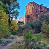
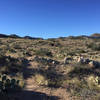
The trail drops down through the cactus down to the creek. The first mile and half hike along the creek is through the cottonwoods. The trail then enters the canyon with red rock soaring on both sides. Many creek crossing.
Need to Know
Open year Round. Only 30 hikers from the west trailhead each day.
You get permits through Recreation.gov
Aravaipa Canyon Wilderness Permits, Aravaipa Canyon Wilderness - Recreation.gov
Description
A green paradise in the middle of Arizona desert.
The year round
Aravaipa Creek is constantly shaded by cottonwoods as it cuts a 1,000-foot-deep canyon through the Galiuro Mountains.
There is a well-marked short trail down to the creek. There is no official trail once you reach the canyon bottom, but often you'll find one or more social trails on the banks. Overall, the general route is obvious.
Expect to get your feet wet, as the easiest progress is frequently by wading in the creek or by crossing from one bank to the other.
The turn around point is at a popular camping area beside the creek between Virgus and Horse Camp side canyons.
Flora & Fauna
Cottonwood, willow, walnut, alder and sycamore trees. Six species of native desert fish may be found here, along with desert bighorn sheep, an extensive variety of large and small mammals and reptiles, and at least 238 species of birds.
Contacts
Shared By:
Stewart Carnes

 Continue with onX Maps
 Continue with Facebook


 Particularly Special Place


 Intermediate/Difficult


0 Comments