
 Continue with onX Maps
 Continue with Facebook


 Particularly Special Place


 Intermediate/Difficult
Intermediate/Difficult
Intermediate/Difficult
 Intermediate/Difficult
Land Manager: USFS - Tonto National Forest Office
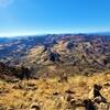
 Picket Post Mountain Trail
4.3 mi 7.0 km • 1,957' Up 596.36 m Up • 1,957' Down 596.36 m Down

 Superior, AZ
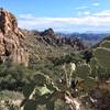
 Weavers Needle Loop
12.7 mi 20.4 km • 2,643' Up 805.52 m Up • 2,637' Down 803.87 m Down
Gold Camp, AZ
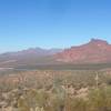
Peak of Interest Loop
9.4 mi 15.1 km • 2,191' Up 667.86 m Up • 2,191' Down 667.73 m Down
 Maricopa Trail - Pass Mountain Connector
9.4 mi 15.1 km • 538' Up 163.95 m Up • 1,335' Down 406.81 m Down
Maricopa Trail: Usery Mountain Visitor's Center to Bulldog
13.1 mi 21.1 km • 1,079' Up 328.87 m Up • 1,079' Down 328.94 m Down
Usery Mountain Regional Park Medium Loop
6.3 mi 10.1 km • 283' Up 86.3 m Up • 278' Down 84.85 m Down
Apache…, AZ


0 Comments