
Local Club: Friends of the Cataraqui Trail
Land Manager: Cataraqui Region Conservation Authority
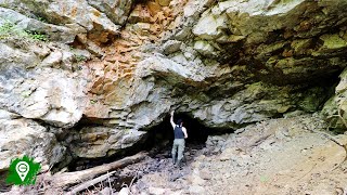
 Silver Queen Mine Trail
1.2 mi 2.0 km • 57' Up 17.45 m Up • 52' Down 15.75 m Down

 Gould Lake North-East Loop
3.1 mi 5.0 km • 325' Up 99.02 m Up • 324' Down 98.89 m Down
Kingston, ON
 Inner Harbour There-And-Back
4.1 mi 6.6 km • 68' Up 20.87 m Up • 69' Down 20.9 m Down
K&P Trail
62.8 mi 101.0 km • 1,320' Up 402.29 m Up • 890' Down 271.27 m Down
Lake Ontario Park
2.3 mi 3.8 km • 65' Up 19.88 m Up • 65' Down 19.89 m Down
Cataraqui Trail (CT)
67.7 mi 108.9 km • 2,048' Up 624.3 m Up • 2,146' Down 654.16 m Down

 Continue with onX Maps
 Sign in with Facebook


 Particularly Special Place


0 Comments