
 Continue with onX Maps
 Continue with Facebook


 Particularly Special Place


 Difficult
Difficult
Difficult
 Difficult
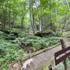
 Bald Mountain Creek Preserve Outer Loop
7.3 mi 11.8 km • 1,875' Up 571.35 m Up • 1,878' Down 572.36 m Down
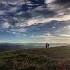
 Max Patch Short Loop
1.5 mi 2.4 km • 242' Up 73.7 m Up • 249' Down 75.89 m Down
 Marshall, NC
 Mount Mitchell - Black Mountain Crest Trail #179
12.1 mi 19.5 km • 5,010' Up 1526.98 m Up • 1,498' Down 456.71 m Down
Burnsville, NC
Tricorner Knob Loop via Appalachian Trail
34.7 mi 55.8 km • 7,017' Up 2138.89 m Up • 7,017' Down 2138.83 m Down
Cove Creek, NC
Mount Mitchell
11.7 mi 18.8 km • 3,651' Up 1112.72 m Up • 3,650' Down 1112.62 m Down
Black M…, NC
Balsam Crosby Figure 8
39.9 mi 64.3 km • 7,563' Up 2305.23 m Up • 7,563' Down 2305.28 m Down


0 Comments