Dogs Leashed

Features
Views
Overview
This is a counterclockwise loop, getting the hard part over first, followed by 9-ish miles of downhills and flats. The views are worth the effort and crowds.
Need to Know
The trail going down is officially called the S Mt Elbert Trail (#1481) - according to the sign at the bottom, but there is no sign at the top. I have also seen it referenced as the East Trail on AllTrails.
Description
The first five miles (
North Trail) is all uphill. It is well-marked and starts at the
Mt. Elbert Trailhead. It goes for about a mile on the Colorado Trail, then turns right on the Mt Elbert
North Trail. You spend a little over another mile in the trees, where the trail is in good shape and isn't that technical (at least compared to trails in the east).
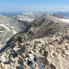
Above the tree line is an exposed section for about another mile with a lot of grass and brush. The trail is in good shape here and isn't too technical. The last section gets very steep and is very rocky. Going up it was ok, but I can see how going down that part would be challenging.
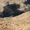
Don't forget to look behind you periodically after you emerge from the tree line. There are some fabulous views.
The second five miles (
South Trail) is all down. From the top, go back (north), maybe 100 meters, and you'll see an unmarked trail to the right. Take that. The terrain and trail conditions match the
North Trail, except the top section isn't as steep or technical as it is on the
North Trail. There was some maintenance and a few minor reroutes in the grassy section (July 2020). The views looking towards Twin Lakes and Leadville are awesome.
The last four or so miles of the Colorado Trail/Continental Divide Trail are pretty flat. The trail is all below the treeline, in great shape, and most of it was pretty fast (again, compared to East Coast trails).
Contacts
Shared By:
John Main

 Continue with onX Maps
 Continue with Facebook


 Particularly Special Place


 Intermediate/Difficult


0 Comments