
 Continue with onX Maps
 Continue with Facebook


 Particularly Special Place


 Intermediate

 Intermediate
Land Manager: Vermont Department of Forests, Parks, and Recreation
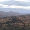
 Little Ascutney Mountain
2.5 mi 4.0 km • 798' Up 243.33 m Up • 798' Down 243.34 m Down
 Sunapee Mountain Out-and-Back
5.1 mi 8.3 km • 1,576' Up 480.23 m Up • 1,575' Down 480.07 m Down
Newbury, NH
 Moose Mountain Trail
4.3 mi 6.9 km • 1,004' Up 306.13 m Up • 1,000' Down 304.88 m Down
Pico Peak via Sherburne Pass Trail
5.5 mi 8.9 km • 1,750' Up 533.44 m Up • 1,750' Down 533.34 m Down
 Pittsfield, VT
Deer Leap Overlook
Pittsfield, VT
Deer Leap Overlook
2.0 mi 3.2 km • 452' Up 137.67 m Up • 452' Down 137.67 m Down
Monadnock - Sunapee Greenway
48.3 mi 77.7 km • 7,936' Up 2418.9 m Up • 8,377' Down 2553.31 m Down


0 Comments