
 Continue with onX Maps
 Continue with Facebook


 Particularly Special Place


 Intermediate
Intermediate
Intermediate
 Intermediate
Land Manager: Legacy Parks Foundation
 Sharp's Ridge Loop
3.3 mi 5.3 km • 452' Up 137.68 m Up • 504' Down 153.56 m Down

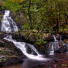
 Abrams Falls Out and Back
5.1 mi 8.2 km • 550' Up 167.56 m Up • 550' Down 167.56 m Down
Maryville, TN
Spruce Flats Falls Trail
1.8 mi 2.9 km • 452' Up 137.73 m Up • 452' Down 137.7 m Down
Gatlinburg, TN
 Gatlinburg Trail
2.8 mi 4.4 km • 102' Up 31.2 m Up • 102' Down 31.15 m Down
Cucumber Gap Loop
5.5 mi 8.8 km • 774' Up 235.94 m Up • 735' Down 224.18 m Down
 Jakes Creek AT Loop
24.5 mi 39.4 km • 4,600' Up 1402.01 m Up • 4,600' Down 1402.23 m Down
Gatlinburg, TN


0 Comments