Use onX Backcountry to explore the terrain in 3D, view recent satellite imagery, and more.
Now available in onX Backcountry Mobile apps!
For more information see this post.
“Shady hike which follows Deer Creek to a nice campsite next to the creek.
”
Features
Birding · Fall Colors · River/Creek · Views · Wildflowers · Wildlife
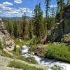
Description
The trail is mainly flat and follows Deer Creek with four small side creek crossings. The trail ends at a campfire rin, and about a dozen camp spots under the forest canopy.
We use cookies to improve your browsing experience, to show you
personalized content, and for statistical purposes. By continuing
to navigate our website, you accept our use of cookies. Read our
Privacy Policy to learn more.

 Continue with onX Maps
 Continue with Facebook


 Particularly Special Place


 Easy
Easy


0 Comments