
 Continue with onX Maps
 Sign in with Facebook


 Particularly Special Place


 Very Difficult
Very Difficult
Very Difficult
 Very Difficult
Land Manager: NPS - Shenandoah National Park
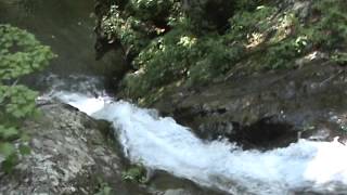
 Cedar Run Trail
3.0 mi 4.8 km • 2,179' Up 664.07 m Up • 19' Down 5.93 m Down

 Stanley, VA
Whiteoak Canyon to Cedar Run Loop
Stanley, VA
Whiteoak Canyon to Cedar Run Loop
8.2 mi 13.1 km • 2,255' Up 687.39 m Up • 2,255' Down 687.38 m Down
Stanley, VA
 Hawksbill Mountain Loop
2.6 mi 4.2 km • 602' Up 183.55 m Up • 649' Down 197.73 m Down
Stanley, VA
 AT/Passamaquoddy/Furnace Springs Loop
2.8 mi 4.5 km • 591' Up 180.22 m Up • 605' Down 184.28 m Down
Old Rag Loop
8.9 mi 14.3 km • 2,362' Up 719.92 m Up • 2,359' Down 718.89 m Down
Stanley, VA
Bearfence Loop Trail
1.0 mi 1.7 km • 218' Up 66.37 m Up • 217' Down 66.27 m Down
Stanley, VA


0 Comments