
 Continue with onX Maps
 Continue with Facebook


 Particularly Special Place


 Intermediate

 Intermediate
Land Manager: Alaska Department of Fish & Game
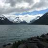
 Portage Pass Trail
4.4 mi 7.2 km • 934' Up 284.68 m Up • 933' Down 284.33 m Down
 Girdwood, AK
 Byron Glacier Trail
1.9 mi 3.0 km • 207' Up 63 m Up • 207' Down 62.98 m Down
Girdwood, AK
Portage Glacier (Winter)
6.1 mi 9.8 km • 820' Up 249.87 m Up • 818' Down 249.41 m Down
Girdwood, AK
 Winner Creek to Hand Tram
5.1 mi 8.2 km • 571' Up 174.16 m Up • 571' Down 174.16 m Down
Girdwood, AK


0 Comments