Use onX Backcountry to explore the terrain in 3D, view recent satellite imagery, and more.
Now available in onX Backcountry Mobile apps!
For more information see this post.
“Connects on both ends to the Bonanza Bill Trail #23 and crosses the state line.
”
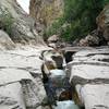
The Tige Rim Trail connects on both ends to the Bonanza Bill Trail #23 (wooden trail signs at interchanges) and crosses the state line. As with the area, it is typical high desert landscape in the pines with rocky and sandy trail. As the trail is quite popular among equestrian trail users, watch your footing from their "droppings".
Starting on the northern end of the trail and heading southeast, the trail is slightly more grade than is runnable for most individuals but is quite suitable to the run/hike/run method. The trail rewards you with several viewpoints and is easy to follow.
We use cookies to improve your browsing experience, to show you
personalized content, and for statistical purposes. By continuing
to navigate our website, you accept our use of cookies. Read our
Privacy Policy to learn more.

 Continue with onX Maps
 Continue with Facebook


 Particularly Special Place


 Intermediate/Difficult


0 Comments