
 Continue with onX Maps
 Continue with Facebook


 Particularly Special Place


 Difficult
Difficult
Difficult
 Difficult
Land Manager: SC State Parks - Caesars Head
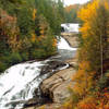
 DuPont Waterfall Bonanza
14.1 mi 22.7 km • 1,472' Up 448.73 m Up • 1,503' Down 458.01 m Down

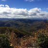
 Pinnacle Trail to Table Rock Loop
10.9 mi 17.6 km • 2,899' Up 883.69 m Up • 2,899' Down 883.75 m Down
Pickens, SC
Carrick Creek Trail
2.0 mi 3.3 km • 353' Up 107.55 m Up • 353' Down 107.46 m Down
Art Loeb Trail
31.1 mi 50.1 km • 7,578' Up 2309.92 m Up • 6,409' Down 1953.61 m Down
 Brevard, NC
 Art Loeb & North Slope Loop
7.4 mi 11.8 km • 1,330' Up 405.5 m Up • 1,329' Down 405.11 m Down
Saluda Mountains Passage
11.9 mi 19.2 km • 1,928' Up 587.69 m Up • 1,929' Down 588.01 m Down


 All Clear


0 Comments