
 Continue with onX Maps
 Continue with Facebook


 Particularly Special Place


 Intermediate

 Intermediate
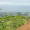
 Sweeny Ridge Loop
5.7 mi 9.1 km • 954' Up 290.82 m Up • 958' Down 292.09 m Down
Water Dog Loop Trail
3.3 mi 5.3 km • 519' Up 158.34 m Up • 521' Down 158.71 m Down
 San Carlos, CA
Mussel Rock Park Tour
San Carlos, CA
Mussel Rock Park Tour
2.2 mi 3.6 km • 310' Up 94.64 m Up • 310' Down 94.47 m Down
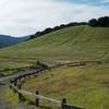
Broadmoor, CA
 Edgewood Nature Preserve Loop
5.7 mi 9.2 km • 1,034' Up 315.3 m Up • 1,028' Down 313.25 m Down
Emerald…, CA
Alambique Loop Trail
1.8 mi 2.9 km • 343' Up 104.68 m Up • 341' Down 104.07 m Down
Woodside, CA
 Stanford Dish: Ranch Road via Piers Gate
2.3 mi 3.7 km • 295' Up 89.99 m Up • 295' Down 89.92 m Down


0 Comments