Dogs No Dogs

Features
Views
Need to Know
There's no restroom or any facility at the summit. The only infrastructure is the shelter at the bottom of the plate. Bring proper warm clothing and gear—it gets cold (reaches freezing temperature at night) quickly after sunset.
Description
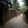
Although there are many informal trails throughout, the most used is obvious to follow. The soil is loose gravel, so step carefully and don't rush it. Once you're above the treeline, you get to see the Agua Volcano to your right. Once you reach the rocks, turn left towards the summit and you'll see a clear road up.
The last 50 meters are hard, but just keep going. The moment you reach the summit, you'll forget all the pain and exhaustion. On a clear day, you can see the Pacific Ocean to the south, Lake Atitlan to the west, along with the many volcanoes.
Flora & Fauna
There's not much here other than dark gravel. You're above the treeline.
Shared By:
Ignacio Basterrechea

 Continue with onX Maps
 Continue with Facebook


 Particularly Special Place


 Difficult


0 Comments