Dogs Unknown

Need to Know
The southern trailhead is located at the end of Forest Service Road 379 (Chandler Road) off Old Whitmire Road (SR 81). Buncombe Trailhead for equestrians is located at Brick House Recreation Area (mile 14) and accessed from SC 66. The northern trailhead is at Sedalia Campground.
For more information on this section of the Palmetto Trail,
click here.
Description
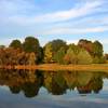
This section of the Palmetto Trail from the south winds 4 miles through pine and hardwood forest with the trail marked in yellow blazes. The terrain is composed of gentle hills with a doubletrack dirt path and occasional water crossings. It crosses Gilders and Indian Creek before joining Buncombe Horse Trail. From the 10-mile marker to the Brick House Campground, this becomes a shared use trail with equestrians. As you progress north, the trail passes a beaver pond, hardwood forest, and the Enoree River. An 80-foot bridge offers good views of the river here.
Contacts
Shared By:
Missouri Hiker

 Continue with onX Maps
 Continue with Facebook


 Particularly Special Place


 Intermediate


 Minor Issues


0 Comments