
 Continue with onX Maps
 Continue with Facebook


 Particularly Special Place


 Easy
Easy

 Easy
Easy
Local Club: Missouri Trails Project
Land Manager: Great Rivers Greenway District
 Podhorn Trail Loop
0.7 mi 1.2 km • 17' Up 5.12 m Up • 16' Down 5 m Down
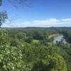
 Castlewood State Park Loop
2.3 mi 3.7 km • 327' Up 99.66 m Up • 327' Down 99.53 m Down
Jack's Loop
4.1 mi 6.5 km • 394' Up 119.98 m Up • 394' Down 119.96 m Down
 Dames Park Figure 8
1.2 mi 1.9 km • 29' Up 8.89 m Up • 29' Down 8.72 m Down
Western Pool Loop
6.5 mi 10.5 km • 52' Up 15.85 m Up • 52' Down 15.84 m Down
 Dresser Island Levee Trail
5.7 mi 9.1 km • 142' Up 43.14 m Up • 140' Down 42.74 m Down


0 Comments