
 Continue with onX Maps
 Continue with Facebook


 Particularly Special Place


 Intermediate/Difficult
Intermediate/Difficult
Intermediate/Difficult
 Intermediate/Difficult
Land Manager: USFS - Arapaho & Roosevelt National Forests Office
 Beaver Creek Hourglass Loop
20.0 mi 32.2 km • 3,612' Up 1100.87 m Up • 3,611' Down 1100.69 m Down

 Red Fea…, CO
 Lulu City Out-and-Back
3.5 mi 5.7 km • 493' Up 150.25 m Up • 257' Down 78.22 m Down
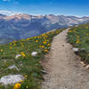
Timber Lake Trail
9.5 mi 15.3 km • 1,972' Up 601.09 m Up • 1,972' Down 600.95 m Down
Grand Lake, CO
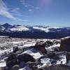
Mount Ida
9.5 mi 15.3 km • 2,231' Up 679.92 m Up • 2,228' Down 679.21 m Down
Grand Lake, CO
 Mount Chiquita
5.2 mi 8.4 km • 1,934' Up 589.57 m Up • 1,934' Down 589.59 m Down
Estes Park, CO
 Beaver Boardwalk
0.1 mi 0.2 km • 3' Up 1 m Up • 3' Down 0.98 m Down


0 Comments