
 Continue with onX Maps
 Continue with Facebook


 Particularly Special Place


 Difficult
Difficult
Difficult
 Difficult
Land Manager: White River National Forest - Maroon Bells
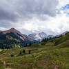
 Capitol Lake, Avalanche Creek, Hell's Roaring Pass Loop
24.6 mi 39.6 km • 6,491' Up 1978.41 m Up • 6,420' Down 1956.74 m Down
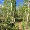
 Aspen to Crested Butte via West Maroon Pass
10.8 mi 17.4 km • 2,878' Up 877.12 m Up • 2,034' Down 619.91 m Down
 Snowmas…, CO
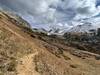
 Intercept Lot to Rodeo Lot via Sky Mountain Park
7.7 mi 12.3 km • 1,206' Up 367.57 m Up • 882' Down 268.94 m Down
Snowmas…, CO
Sunnyside–Radio Tower
4.8 mi 7.7 km • 1,501' Up 457.56 m Up • 1,501' Down 457.64 m Down
Aspen, CO
Rustler Gulch Out and Back
7.7 mi 12.3 km • 1,271' Up 387.47 m Up • 1,271' Down 387.49 m Down
Crested…, CO
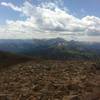
Mount Sopris
13.4 mi 21.5 km • 4,228' Up 1288.82 m Up • 4,228' Down 1288.66 m Down
El Jebel, CO


0 Comments