
 Continue with onX Maps
 Continue with Facebook


 Particularly Special Place


 Easy/Intermediate

 Easy/Intermediate
Land Manager: City of Medford - Parks, Recreation and Facilities
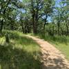
 Britt Woods Loop
5.1 mi 8.2 km • 786' Up 239.45 m Up • 790' Down 240.67 m Down
 Grizzly Peak Loop Trail
5.1 mi 8.3 km • 839' Up 255.58 m Up • 838' Down 255.57 m Down
 Ashland, OR
Sterling Mine Ditch Trail Out and Back
Ashland, OR
Sterling Mine Ditch Trail Out and Back
34.9 mi 56.2 km • 3,182' Up 969.75 m Up • 3,184' Down 970.59 m Down
Jackson…, OR
 Viewpoint Mike Trail
5.0 mi 8.0 km • 1,008' Up 307.32 m Up • 1,008' Down 307.26 m Down
Pilot Rock Trail
3.0 mi 4.8 km • 625' Up 190.62 m Up • 626' Down 190.7 m Down
Ashland, OR
Boccard Point
10.1 mi 16.2 km • 1,489' Up 453.93 m Up • 1,487' Down 453.15 m Down
Ashland, OR


 All Clear


0 Comments