
 Continue with onX Maps
 Continue with Facebook


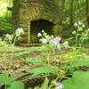
 Particularly Special Place


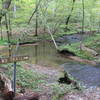
 Intermediate
Intermediate
Intermediate
 Intermediate
Land Manager: Tennessee State Parks
 Red, White, and Blue
11.2 mi 18.0 km • 1,340' Up 408.55 m Up • 1,342' Down 409.11 m Down

 Forest…, TN
 Black, Blue, Green, and Red Trails
4.2 mi 6.8 km • 500' Up 152.28 m Up • 509' Down 155.22 m Down
Garrison Creek Trail
3.9 mi 6.2 km • 399' Up 121.48 m Up • 400' Down 121.79 m Down
War of 1812 Memorial to Tennessee Divide
5.6 mi 9.0 km • 534' Up 162.91 m Up • 535' Down 162.94 m Down
North Loop
6.1 mi 9.8 km • 555' Up 169.05 m Up • 586' Down 178.63 m Down
Bledsoe Creek State Park Main Loop
3.3 mi 5.4 km • 393' Up 119.68 m Up • 394' Down 119.96 m Down


 All Clear


0 Comments