Dogs Unknown

Description
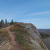
This trail is the first segment of the Point Trail, which will hopefully extend all the way out to the end of Keweenaw Point. This non-motorized, multi-use path will eventually connect the great trails near Copper Harbor with the end of the Point, allowing users to create loops and routes of varying length.
This section was recently completed and is generally a mellow path. The area has some unique terrain with a conglomerate rock surface in areas. The trail itself is moderately rolling, though grades are gentle. At the east end, there is a very long wooden boardwalk.
The trail is part of the trail system's expansion to the Keweenaw Point. Visit
copperharbortrails.org/ for more information on the project.
Shared By:
Jeff B.

 Continue with onX Maps
 Continue with Facebook


 Particularly Special Place


 Intermediate


0 Comments